factograf
EN
Sign in

country in South America

Suriname

Suriname

Suriname, officially the Republic of Suriname, is a country on the northern coast of South America that is also considered part of the Caribbean region. Situated slightly north of the equator, over 90% of its territory is covered by rainforest, the second-highest proportion of forest cover in the world. It is the smallest sovereign country in South America by both population and territory, and its capital and largest city, Paramaribo, is home to roughly half of its inhabitants.

Colonial history

Slave auction in Paramaribo, in 1831
Javanese indentured servants on the Marienbourg plantation, around 1930
Suriname in 1914
Suriname in 1914
Presidential Palace of Suriname
Maroon village along the Suriname River, 1955
Waterfront houses in Paramaribo, 1955
Prime Minister Henck Arron, future queen Beatrix of the Netherlands and President Johan Ferrier on 25 November 1975
Protesters stormed the National Assembly building in February 2023
Brokopondo Reservoir surrounded by tropical rainforest
The Coppename River, one of many rivers in the interior
Map of Suriname with disputed territories in light green.
Seasons in Suriname
Seasons in Suriname
12 images

Indigenous peoples, including the Lokono, Kalina, and Wayana, lived in the area thousands of years before Europeans arrived in the 16th century. By the late 17th century the Dutch controlled much of the present territory, and Suriname became a profitable plantation colony focused mainly on sugar, worked by enslaved Africans until slavery was abolished in 1863. Indentured workers from British India and the Dutch East Indies were later recruited to replace them.

Independence and society

Ministry of Finance
Ministry of Finance
Central Bank of Suriname building in Paramaribo
Central Suriname Nature Reserve seen from the Voltzberg
The remains of the synagogue at Jodensavanne
Fort Zeelandia in Paramaribo
The Cathedral of St. Peter and Paul in Paramaribo
Jules Wijdenbosch Bridge over the Suriname River
Johan Adolf Pengel International Airport
Population of Suriname from 1961 to 2003, in thousands; the slowdown and decline around 1969–1985 reflects mass migration to the Netherlands and French Guiana.
Immigrants from India
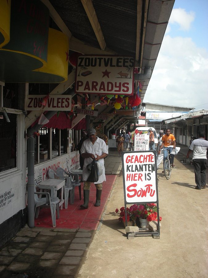
Butcher in the Central Market in Paramaribo with signs written in Dutch
A Sranan Tongo poetry sign located in Rotterdam, Netherlands
12 images

In 1954 Suriname became a constituent country of the Kingdom of the Netherlands, and it gained independence on 25 November 1975 after negotiations with the Dutch government. Dutch is the official language and is the native tongue of an estimated 60% of the population, while Sranan Tongo serves as a widely used lingua franca. No ethnic group forms a majority, and the country's economy depends heavily on bauxite, gold, petroleum, and agriculture.

In 240 languages

EnglishČeštinaDeutschEspañolFrançaisItaliano日本語PolskiPortuguêsРусскийУкраїнська中文AbkhazianAcehneseAfrikaansShqipAmiአማርኛOld EnglishAngikaAragoneseالعربيةMoroccan ArabicEgyptian ArabicAsturianuAwadhiAymaraAzbAzərbaycanBalineseBavarianbat-smgБашҡортBikolБеларускаяBetawiБългарскиBhojpuriBislamaবাংলাབོད་སྐད་BishnupriyaBrezhonegBosanskiБуряадCatalàcbk-zamCdoCebuanoНохчийнکوردیی ناوەندیCorsicanCrimean TatarЧӑваш чӗлхиCymraegDagDanskZazaDolnoserbšćinaDtyDivehiརྫོང་ཁEʋegbeΕλληνικάEsperantoEestiEuskaraExtremaduranفارسیfiu-vroSuomiFøroysktArpitanNorthern FrisianFryskGagauzGaeilgeGcrGàidhligGilakiGalegoGuaraniकोंकणीGothicWayuuગુજરાતીGaelgHakka ChineseHausaʻŌlelo HawaiʻiעבריתFiji Hindiहिन्दीHrvatskiHornjoserbšćinaHaitian CreoleMagyarՀայերենInterlinguaIbanBahasa IndonesiaInterlingueIgboIlokoIdoÍslenskaJamaican Creole EnglishLojbanJawaKara-KalpakTaqbaylitქართულიKabardianGikuyuҚазақшаಕನ್ನಡ한국어Karachay-BalkarکٲشُرKurdî (kurmancî)KernewekКыргызчаLadinoLatinLëtzebuergeschLingua Franca NovaLigureLimburgishLldLombardLingálaລາວLatgalianLietuviųLatviešuMadureseमैथिलीmap-bmsMokshaMalagasyMariMinangkabauMāoriМакедонскиമലയാളംমৈতৈলোন্МонголWestern MariमराठीMelayuMaltiမြန်မာمازرونیNeddersass’sch (Nedderlannen)Neddersass’schनेपालीNewariNederlandsNorsk nynorskNovialNorskNupNavajoOccitanOloOromooИронPampangaPapiamentoਪੰਜਾਬੀPennsylvania GermanPiemontèisWestern PanjabiپښتوRunasimiRkiRumantschRomânăIkinyarwandaСаха тылаᱥᱟᱱᱛᱟᱲᱤSicilianuScotsSarduسنڌيDavvisámegiellaတႆးSrpski (latinica)සිංහලSlovenčinaSlovenščinaAnarâškielâSamoanChiShonaSoomaaliShqipSranan TongoСрпскиSaterland FrisianBasa SundaSvenskaKiswahiliŚlōnskiSzyதமிழ்TayTetumతెలుగుТоҷикӣไทยትግርኛTürkmen diliFilipinoTalyshToki ponaLea fakatongaTok PisinTarokoTürkçeТатарTumbukaUdmurtئۇيغۇرچەاردوO‘zbekVenetoVepsTiếng ViệtWest FlemishVolapükWarayWalloonWolofWu ChineseMingrelianייִדישÈdè YorùbáVahcuenghZeelandiczh-yue

Редакція Factograf · Published October 14, 2026 · Partly based on Wikipedia, CC BY-SA 4.0 · Source article